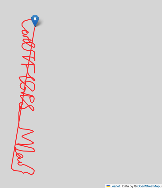
我在刷攻防世界 CatchCat 这道题目时,看到附件是一些GPS数据,猜测需要绘制GPS轨迹,因此想到使用 Python 来绘制。
GPS数据有一定的格式规范,常见的有 GPRMC、GPGGA等,本文介绍的是利用 python 的 pynmea2、folium 两个库对 GPGGA 格式的解析和图形绘制。
Python 版本 Python 3.10.9
pynmea2 版本 1.19.0
folium 版本 0.14.0
参考了网上的文章,这里直接把代码贴出来:
1
2
3
4
5
6
7
8
9
10
11
12
13
14
15
16
17
18
19
20
21
22
23
24
25
26
27
28
29
30
31
32
33
34
35
36
37
38
39
40
41
42
43
44
| import pynmea2
import folium
import os
def draw_gps(location1, location2, color1, color2):
m1 = folium.Map(location1[0], zoom_start=15, attr='default')
m2 = folium.Map(location2[0], zoom_start=15, attr='default')
folium.PolyLine(
location1,
weight=3,
color=color1,
opacity=0.8
).add_to(m1)
folium.PolyLine(
location2,
weight=3,
color=color1,
opacity=0.8
).add_to(m2)
folium.Marker(location1[0], popup='<b>Starting Point</b>').add_to(m1)
folium.Marker(location2[-1], popup='<b>End Point</b>').add_to(m2)
m1.save(os.path.join('13.HTML'))
m2.save(os.path.join('21.HTML'))
locations = []
gps_file = "CatchCat.txt"
f = open(gps_file, encoding='utf-8')
text = f.readline()
while text:
msg = pynmea2.parse(text)
print(msg.latitude)
print(msg.longitude)
locations.append([msg.latitude,msg.longitude])
text = f.readline()
f.close()
|
如果本地没有 pynmea3、folium 库,请通过 pip3 安装
执行代码后可以看到本地有个 13.html ,使用浏览器打开。默认生成的文件中使用了 jsdelivr 的CDN地址,因为现在国内已经不能使用了,可以改成下面的地址
1
2
3
4
5
6
7
8
9
10
| <script src="https://unpkg.com/leaflet@1.9.0/dist/leaflet.js"></script>
<script src="https://code.jquery.com/jquery-1.12.4.min.js"></script>
<script src="https://unpkg.com/bootstrap@5.2.2/dist/js/bootstrap.bundle.min.js"></script>
<script src="https://cdnjs.cloudflare.com/ajax/libs/Leaflet.awesome-markers/2.0.2/leaflet.awesome-markers.js"></script>
<link rel="stylesheet" href="https://unpkg.com/leaflet@1.9.0/dist/leaflet.css"/>
<link rel="stylesheet" href="https://unpkg.com/bootstrap@5.2.2/dist/css/bootstrap.min.css"/>
<link rel="stylesheet" href="https://netdna.bootstrapcdn.com/bootstrap/3.0.0/css/bootstrap.min.css"/>
<link rel="stylesheet" href="https://unpkg.com/@fortawesome/fontawesome-free@6.2.0/css/all.min.css"/>
<link rel="stylesheet" href="https://cdnjs.cloudflare.com/ajax/libs/Leaflet.awesome-markers/2.0.2/leaflet.awesome-markers.css"/>
<link rel="stylesheet" href="https://unpkg.com/gh/python-visualization/folium/folium/templates/leaflet.awesome.rotate.min.css"/>
|
最后还是有一个 css 没能正常加载,但是对于 ctf 题目来说不重要,因为并不需要知道地图是在什么位置。

参考资料
- folium 实用功能进阶
- leafletjs
- GPS数据Python解析及地图可视化

